Earthquake in Texas, now you can see where when and how large.
Texas always had some natural earthquake activity throughout its history, but that activity seems to be increasing, and despite mounting evidence that oil and gas activity has triggered all of the recent earthquakes in Dallas and Fort Worth, Texas regulators have consistently questioned the link.
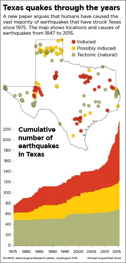 A study by researchers at the University of Texas and Southern Methodist University argues that humans have been causing earthquakes not just in North Texas but throughout the state for nearly 100 years. The paper, concludes that activities associated with petroleum production “almost certainly” or “probably” set off 59 percent of earthquakes across the state between 1975 and 2015, including the recent earthquakes in Irving and Dallas.
Another 28 percent were “possibly” triggered by oil and gas activities. Scientists deemed only 13 percent of the quakes to be natural.
Between 1980 and about 2010 there were one to two earthquakes per year in the entire state. Between 2010 and 2015 that rate of seismicity changed to up to 15 small earthquakes per year. The number of earthquakes continues to rise, with 28 earthquakes recorded in Texas in 2016.
Almost a decade ago, the ground around the densely populated Dallas-Fort Worth Metroplex started shaking. As the frequency and intensity of earthquakes increased in a region poorly prepared for the seismic activity, the risk became a priority for the state.
In the 84th and 85th Legislative Sessions, the Texas Legislature tasked the Bureau of Economic Geology in the Jackson School of Geosciences at The University of Texas at Austin with helping to locate and determine the origins of earthquakes in our State, and, where they may have been caused by human activity, help to prevent them from occurring in the future. And in June 2015, Texas Gov. Greg Abbott and the 84th Legislature authorized $4.47 million for TexNet.
Since then, the Bureau’s TexNet research team has developed the TexNet Earthquake Catalog, a dynamic mapping web page, which provides information on the location of monitoring stations, and recorded earthquakes across the state. Check it out – http://www.beg.utexas.edu/texnet